
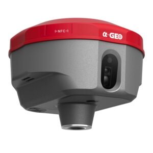
PERFECT ROVER :
Integration of Industrial art ad advanced technologies. 1008 channesl, full star satelite tracking, first-tier IMU, full GNSS support, all in the palm size.
VERSATILE, RUGGED, ACCURATE
- 100% more efficient to do surveying and staking-out
- 41% better performance in canopy environments
- Lifetime online face-to-face services
- Much easier RTK operations
- Enhanced signals tracking
- One click to all functions
- Comprehensice staking out
- Super accuracy
- connections in seconds
- cloud based management
100% MORE EFFICIENT TO DO SURVEYING AND STAKING-OUT
- 1008 channels, full support of all GNSS constellations.
- Advanced Full Start technology, to maximize the use of all the satellite signals.
- 4D IMU
- Ekeeping technology, maintain fixed positioning when real-time corrections are lost.
MEASURE ANYWHERE, WHEN YOU GET THERE
Double check technology, using mulit-frequencys to solve GNSS signal, smart select
- GNSS-IMU tight couping, using one epoch to get fix ambiguity
- 41% performance improvement
RTK CAN BE MUCH EASIER
- Cable free, Bluetooth radio, work without complex connections.
- Cloud-based data management
- One click to all functions Userfriendly interface, make it easy to understand and use; Supermenu, one click to access all functions.
- Staking-out from CAD basemap click to select the points to stake.
- Data sharing by bar code scanning.
📡 Spesifikasi GNSS Geodetik
| GNSS Performance | |
|---|---|
| Channels | 1008 |
| Satellites Tracking | BDS: B1I/B2I/B3I/B1C/B2a GPS: L1/L2/L5 GLONASS: L1/L2 Galileo: E1/E5a/E5b QZSS: L1/L2/L5 |
| Positioning Rate | Up to 20 Hz |
| Operating System | Linux |
| Initialization Time | < 5 sec |
| Initialization Reliability | > 99.9% |
| Post-processing Static Accuracy | Horizontal: 2.5 mm + 0.5 ppm Vertical: 5 mm + 0.5 ppm |
| Real-Time Kinematics (RTK) Accuracy | Horizontal: 8 mm + 1 ppm Vertical: 15 mm + 1 ppm |
| IMU Sensor | |
| IMU | Supported |
| Accuracy | Less than 2.5 cm within 30° |
| Tilt Angle | 0° ~ 60° |
| Hardware | |
| Size (L × W × H) | 121 mm × 121 mm × 74 mm |
| Weight | 0.87 kg |
| Button | Power button |
| Operating Temperature | -45°C ~ +75°C |
| Storage Temperature | -45°C ~ +85°C |
| Water/Dust Proof | IP67 |
| Shock Resistance Grade | IK08 |
| Shock | Survive a 2 m drop |
| Data Output | |
| Correction Data | CMR, RTCM2.X, RTCM3.X, Full Star |
| GPS Data | NEMA 0183, PJK, Binary |
| Feature | |
| Intelligent Voice | Data collector voice |
| Cloud Service | Remote assistance, data sharing, etc. |
| Static Data Recording | |
| Format | RINEX |
| Data Storage | 8G internal memory |
| Electrical | |
| Battery Capacity | Rechargeable and built-in Lithium-ion battery, 6,800 mAh |
| Working Time | 15 hours with Ntrip work mode |
| External Power | USB Type-C power, powerbank supported |
| Communication | |
| Ports | 1 × USB Type-C port (data download, firmware update) 1 × UHF antenna port (TNC female) |
| Bluetooth | Supported |
| Wi-Fi | Supported |
| Webpage Configuration | Supported |
| NFC | Supported |
| UHF Radio | Standard Internal Rx: 450 – 470 MHz Protocol: Transparent, TT450 S |
Ulasan
Belum ada ulasan.